
MDPS is a powerful package for integrated processing and interpretation of marine geophysical data.
It allows bathymetric, sub-bottom profiling, reflection seismic, side-scan sonar and magnetometer data to be concurrently processed, visualised and exported to surface modelling, CAD and GIS systems.
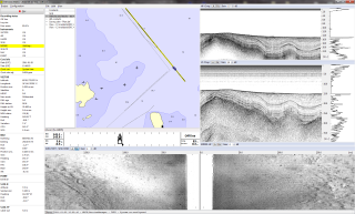
Fast and intuitive map interface
All survey data and survey-related data is visualised as map layers.
Raw data is directly accessible via point and click on the map.
Right: M
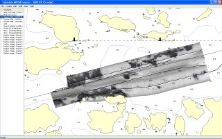
MDPS data processing and interpretation software
DPS Projector map interface portraying ENC data, side-scan sonar mosaic and survey runlines.
Bathymetry data processing
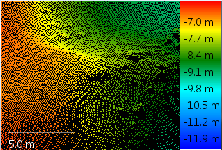
meridata bathymetry software
MDPS can automatically processes vast numbers of depth points to allow efficient bathymetric data cleaning.
Moreover, MDPS has versatile visualisation and editing tools that allow fast access to and inspection of soundings in finest detail.
Right: MDPS Point Cloud Cleaner display for multibeam echosounder data cleaning.
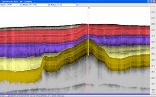
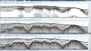
Multi-frequency sub-bottom profiling data interpretation
Interpretation is further aided by a number of productivity-boosting features such as survey line crossing interpretation, use of core sample data, and interpretation integrity checking function.
Right: MDPS Profiler display for sub-bottom profiler data interpretation.

Multi-frequency sub-bottom profiling data interpretation
Side scan data processing and interpretation
The ability to concurrently process survey data from multiple acoustic sources enables you to quickly obtain a full picture of both the seabed and the sub-seabed.
Right: MDPS Projector display showing a side scan sonar mosaic from one survey line, with coloured stripe indicating seabed surfacial material interpreted from the sub-bottom profile seen on the small MDPS Profiler display.
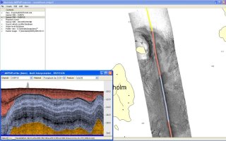
Side scan data processing and interpretation


Leave A Comment